

- Visiting Iceland
- Travel Information
- FAQ
- Protected Areas
- Westfjords
- Breidafjordur
- Dynjandi in Arnarfjordur
- About the area
- Access and services
- Pay for parking
- Nature
- Culture and history
- Drone use at Dynjandi
 Dynjandi in Arnarfjordur
 - Flatey in Breidafjordur
- Hornstrandir
- Hrisey, Reykholahreppur
- Látrabjarg
- For seafarers
Látrabjarg - Surtarbrandsgil
- Vatnsfjordur
Westfjords - North West
- North East
- Boggvistadafjall
- Dettifoss and a row of waterfalls
- Dimmuborgir
- Public park in Glerardalur
- Reservation in Svarfadardalur
- Godafoss in Thingeyjarsveit
- Hraun in Oxnadalur
- Hverastrytur in Eyjafjordur
- Hverfjall
- Krossanesborgir
- Myvatn and Laxa
- Seljahjallagil
- Skutustadagigar
- Vatnajokull National Park
- Vestmannsvatn
North East - West
- Andakill
- Bardarlaug, Snaefellsbaer
- Blautos and Innstavogsnes
- Breidafjordur
- Budahraun
- Einkunnir, Borgarbyggd
- Eldborg in Hnappadalur
- Geitland, Borgarbyggd
- Grabrokargigar, Borgarbyggd
- Grunnafjordur
- Hraunfossar, Borgarbyggd
- Husafellsskogur, Borgarbyggd
- Kalmanshellir
- Melrakkaey
- Stedji (Staupasteinn)
- The coast by Stapi and Hellnir
- Vatnshornsskogur, Skorradalur
- Snaefellsjokull National Park
West - Search by name
- East
- South West
- Akurey
- Alafoss, Mosfellsbaer
- Astjorn, Hafnarfjordur
- Astjorn and Asfjall, Hafnarfjordur
- Bakkatjorn, Seltjarnarnes
- Blafjoll Public Park
- Borgir, Kopavogur
- Bringur, Mosfellsdalur
- Burfell, Gardabaer
- Eldborg in Blafjoll
- Eldborg in Geitahlid
- Eldey, Reykjanesbaer
- The shore by Kasthusatjorn
- Fossvogsbakkar, Reykjavik
- Gardahraun, Gardabaer
- Galgahraun, Gardabaer
- Grotta, Seltjarnarnes
- Hamarinn, Hafnarfjordur
- Haubakkar, Reykjavik
- Hleinar, Hafnarfjordur
- Hlid, Alftanes
- Hvaleyrarlon and Hvaleyrarhofdi
- Kaldarhraun and Gjarnar
- Kasthusatjorn, Alftanes
- Laugaras, Reykjavik
- Litluborgir, Hafnarfjordur
- Raudholar, Reykjavik
- Reykjanes Public Park
- Skerjafjordur, Gardabaer
- Skerjafjordur, Kopavogur
- Stekkjarhraun, Hafnarfjordur
- Trollaborn, Lækjarbotnar
- Tungufoss, Mosfellsbaer
- Valhusahaed, Seltjarnarnes
- Varmarosar, Mosfellsbaer
- Vifilsstadavatn, Gardabaer
- Vigholar, Kopavogur
South West - South
- Alftaversgigar
- Arnahellir in Leitahraun
- Dverghamrar
- Dyrholaey
- Fjallabak Nature Reserve
- Geysir Area
- Gullfoss
- Herdisarvik
- Jorundur in Lambahraun
- Kerlingarfjoll
- Kirkjugolf
- Oddaflod
- Pollengi and Tunguey
- Skogafoss
- Surtsey
- Area in Thjorsardalur
- Vatnajokull National Park
- Videy in Thjorsa
- Thingvellir National Park
- Thjorsarver
South - Mývatn and Laxá
- National Parks
Protected Areas - Westfjords
- Permits in protected areas
- Operational licence
- Photography, cinematography and drone flying
- Research permit
Permits in protected areas - Drones in protected areas
- Guidelines for using drones in protected areas
- Flights in protected areas
- Apply for permit
Drones in protected areas - Volunteers
- Snæfellsjökull National Park
Visiting Iceland - Wildlife
- Air & Climate
- Air pollution during a volcanic eruption
- EU ETS
Air & Climate - Ocean & Water
- Industry
- Chemicals
- Frequently asked questions
- Biocides
- Classification and labelling – CLP
- Cosmetics
- Detergents
- Fluorinated greenhouse gases (F-gases)
- Fuel
- Certificate for pest control
- Certificate for professional use of plant protection products
- Plant protection products
- POPs
- REACH
- Safety data sheets
- Supervision, inspection and coercive measures
Frequently asked questions - Biocides
- Classification and labelling
- CLP
- Classification
- Labelling
- Packaging and retention
Classification and labelling - Cosmetics
- Detergents
- F-gases
- Fuel
- Plant protection products
- Authorisation
- Harmonised Risk Indicators
Plant protection products - POPs
- REACH
- Fees
Chemicals - Frequently asked questions
- Importation of Alien Species
- ETS
Industry - Chemicals
- Circular Economy
- Waste
- Waste Management
Circular Economy - The Agency
Vinna við nýjar heimasíður Umhverfis- og orkustofnunar og Náttúruverndarstofnunar er í gangi. Heimasíða Umhverfisstofnunar er virk á meðan vinnunni stendur. Information in English
.svg)
Neskaupstadur Public Park
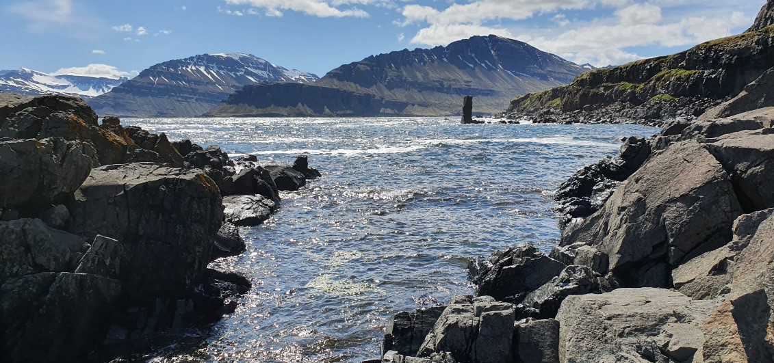
The protection of the Neskaupsstaður country park was approved in 1972, and it was the first country park in Iceland. The country park is ideal for outdoor activities, nature viewing and education, as the landscape is majestic, the ecosystem rich and the geological formations diverse.
Country parks are areas that are protected as areas for outdoor activities and general public use in collaboration with the relevant municipalities. The aim of the protection of Neskaupsstaður Fólksvangur is to preserve sites of natural interest in the area in as untouched a form as possible.
Geological Formations
The outermost part of the mountain range between Norðfjörður and Mjóifjörður is called Norðfjarðarnípa, or Nípa. The boundaries of the country park are on the east of Nípa from the mountain ridge to the sea, in addition to which the protection covers the shallows from the beach.
Nípa is made from basalt lava layers of differing thickness that slope slightly inland. In many places, the lava layers are intercut with rock tunnels. On the beach below Nípa are remains of rock tunnels that have survived the intrusion of the sea and form stacks just offshore. In many places, the surf has also scoured caves in the lava layer, with Páskahellir being the largest.
The lower terrace of Nípa, Hagi, is considered to be an old surf embankment, partly due to the smooth and steep basalt layers above it and the boulder rocks below.
Vegetation
Before the area was protected, it was used as grazing grounds, but after 1970 when grazing ceased, the vegetation has undergone major changes. Instead of grassy fields, flowers, heath and willow are now dominant.
Species diversity is high in the country park, and vegetation is lush in many places. On slopes where snow provides protection in winter and there is shelter in summer, a lot of flowers grow, but in wetlands, sedges, scheuchzeria and cottongrass are more common. In drier areas are grasses and heathland, and in some places, a little scrub. In the rocks and cliffs by the sea you’ll find halophil plants, e.g. scurvy grass, roseroot, sea plantain and oyster plant. The characteristic plants of the Eastfjords, chickweed wintergreen, yellow mountain saxifrage, Faeroic lady’s mantle and bluebell, all grow in the country park. Rare species have also been found there, such as purging flax, pyramidal saxifrage, alpine lady-fern, goldilocks buttercup, common dog-violet, pyramidal bugle, flea sedge and pill sedge.
Wildlife
There is diverse birdlife in the country park. There is a robust bird settlement by Hagi and Nípa, and various cliff birds nest in the sea cliffs. Fulmar and black-legged kittiwake are common, as are herring gull, great black-backed gull and puffin. There are eider ducks by the beach, and cormorants are often spotted, particularly in the winter. Various species of waders and moorland birds also nest in other areas of the country park.
On the beach, you will find various small animals connected to the ecosystem of the beach, in addition to which barnacles and snails are found on many rocks by the beach. In areas further from the beach, you’ll find black slugs and corpse snails. Agabus bipustulatus can be found in peat pits.
Cultural Heritage
By Hálsalækur in Neðri Hálsar are the remains of Brytaskáli and old sheep-related structures.
Points of Interest
To get to the Neskaupsstaður country park, drive Norðfjarðarvegur No. 50, then Egilsbraut, Nesgata and finally, Bakkavegur. There are parking lots at the end of the road, where hiking trails through the country park begin.
There are six marked hiking trails in the country park that can be seen on the hiking trail map.
- The hiking trail in Hagi is easily passable. The trail runs through grassy lowlands out to Páskahellir. Large boulders have fallen from the cliffs above Hagi and form rock heaps called Urðir. Information signs with descriptions of various natural phenomena have been put up on the trail. Above Brytaskáli is the so-called Skálasnið, and through there, it is possible to hike up to Hagaklettar and along the cliffs above them and back. Handholds have been put up in Skálasnið for an easier ascent.
- Páskahellir is in direct continuation from Hagi; to get to it, use the wooden stairs to get down to the beach. You can go out on the rocky beach and up just outside the cave. Handholds have been put up for an easier ascent. In Páskahellir are holes made by trees that are the remains of a forest submerged by lava around 12 million years ago. The trail from the parking lot to Páskahellir is approx. 1 km long.
- Hundsvík. The trail to Hundsvík is a direct continuation of the hiking trail in Hagi which ends by Páskahellir. This trail is slightly more difficult than the one in Hagi. The trail goes through Hundsvíkurvellir to Hundsvík through steep hills and ravines. The trail from the parking lot to Hundsvík is approx. 2 km.
- The rock belt above Hagar is called Hagaklettar. Hiking from Hagaklettar to Skálasnið is easy. On the hike, you’ll see a prominent boulder eroded by the glacier. The trail from the parking lot to Skálasnið is approx. 1 km.
- Þúfustígur is in direct continuation from the Hagaklettar hiking trail. The trail runs within the hiking trail to Hagaklettar, up Efri-Hálsar and along the ridges to Skálahnaus. Þúfa is the name of a vegetated rock protuberance with a large boulder, on the far end of Efri Háls. The view from there is very good. Outside of Þúfa is Breiðarák, also known as Göngurák. Further out, Nípa becomes even steeper, with vertical rock belts and unstable streaks in between. The path from the parking lot to Þúfa is 1.5 km.
- Nípukollur. This trail is for experienced hikers. The hike starts at the foot of the mountain up alongside the outer banks of Stórilækur. Then the trail crosses the stream and goes up steep landslides and rock belts, just inside of Stóralækjargil. Once you reach the mountain ridge, hike out to Nípukollur, 819 m above sea level at its highest peak. There’s a beautiful view from Nípukollur, such as along Nípufjallsröður and over Norðfjarðarflói, and there should be a guestbook inside a cairn.
Please note that the trail to Nípukollur is only marked to the bottom of the rock belt, but from there, the trail is quite obvious along a rock tunnel through the rock belts and onwards up to the mountain ridges.
Rules of Conduct
- Pedestrians are permitted in the area, provided good conduct is observed in every aspect.
- Please refrain from cutting vegetation and causing unnecessary disruption to the wildlife.
- It is forbidden to disturb fixed geological formations in the area.
- All motor vehicle traffic through the country park is prohibited.
- All use of firearms is prohibited in the area and off its coast, except for the extermination of vermin with the permission of XXXXX.
- All construction and soil extraction is prohibited in the area but repairing hiking trails and other measures to facilitate pedestrian traffic as deemed necessary is permitted.
- Grazing is prohibited in the area.
Administration – Operation/Management
The Neskaupsstaður country park was protected in 1972 with notice No. 333 in the Official Journal B. The area is managed by the Fjarðarbyggð municipality.