

- Visiting Iceland
- Travel Information
- FAQ
- Protected Areas
- Westfjords
- Breidafjordur
- Dynjandi in Arnarfjordur
- About the area
- Access and services
- Pay for parking
- Nature
- Culture and history
- Drone use at Dynjandi
 Dynjandi in Arnarfjordur
 - Flatey in Breidafjordur
- Hornstrandir
- Hrisey, Reykholahreppur
- Surtarbrandsgil
- Vatnsfjordur
Westfjords - North West
- North East
- Boggvistadafjall
- Dettifoss and a row of waterfalls
- Dimmuborgir
- Public park in Glerardalur
- Reservation in Svarfadardalur
- Godafoss in Thingeyjarsveit
- Hraun in Oxnadalur
- Hverastrytur in Eyjafjordur
- Hverfjall
- Krossanesborgir
- Myvatn and Laxa
- Seljahjallagil
- Skutustadagigar
- Vatnajokull National Park
- Vestmannsvatn
North East - West
- Andakill
- Bardarlaug, Snaefellsbaer
- Blautos and Innstavogsnes
- Breidafjordur
- Budahraun
- Einkunnir, Borgarbyggd
- Eldborg in Hnappadalur
- Geitland, Borgarbyggd
- Grabrokargigar, Borgarbyggd
- Grunnafjordur
- Hraunfossar, Borgarbyggd
- Husafellsskogur, Borgarbyggd
- Kalmanshellir
- Melrakkaey
- Stedji (Staupasteinn)
- The coast by Stapi and Hellnir
- Vatnshornsskogur, Skorradalur
- Snaefellsjokull National Park
West - Search by name
- East
- South West
- Akurey
- Alafoss, Mosfellsbaer
- Astjorn, Hafnarfjordur
- Astjorn and Asfjall, Hafnarfjordur
- Bakkatjorn, Seltjarnarnes
- Blafjoll Public Park
- Borgir, Kopavogur
- Bringur, Mosfellsdalur
- Burfell, Gardabaer
- Eldborg in Blafjoll
- Eldborg in Geitahlid
- Eldey, Reykjanesbaer
- The shore by Kasthusatjorn
- Fossvogsbakkar, Reykjavik
- Gardahraun, Gardabaer
- Galgahraun, Gardabaer
- Grotta, Seltjarnarnes
- Hamarinn, Hafnarfjordur
- Haubakkar, Reykjavik
- Hleinar, Hafnarfjordur
- Hlid, Alftanes
- Hvaleyrarlon and Hvaleyrarhofdi
- Kaldarhraun and Gjarnar
- Kasthusatjorn, Alftanes
- Laugaras, Reykjavik
- Litluborgir, Hafnarfjordur
- Raudholar, Reykjavik
- Reykjanes Public Park
- Skerjafjordur, Gardabaer
- Skerjafjordur, Kopavogur
- Stekkjarhraun, Hafnarfjordur
- Trollaborn, Lækjarbotnar
- Tungufoss, Mosfellsbaer
- Valhusahaed, Seltjarnarnes
- Varmarosar, Mosfellsbaer
- Vifilsstadavatn, Gardabaer
- Vigholar, Kopavogur
South West - South
- Alftaversgigar
- Arnahellir in Leitahraun
- Dverghamrar
- Dyrholaey
- Fjallabak Nature Reserve
- Geysir Area
- Gullfoss
- Herdisarvik
- Jorundur in Lambahraun
- Kerlingarfjoll
- Kirkjugolf
- Oddaflod
- Pollengi and Tunguey
- Skogafoss
- Surtsey
- Area in Thjorsardalur
- Vatnajokull National Park
- Videy in Thjorsa
- Thingvellir National Park
- Thjorsarver
South - Mývatn and Laxá
- National Parks
Protected Areas - Westfjords
- Permits in protected areas
- Operational licence
- Photography, cinematography and drone flying
- Research permit
Permits in protected areas - Drones in protected areas
- Guidelines for using drones in protected areas
- Flights in protected areas
- Apply for permit
Drones in protected areas - Volunteers
- Snæfellsjökull National Park
Visiting Iceland - Wildlife
- Air & Climate
- Ocean & Water
- Industry
- Chemicals
- Frequently asked questions
- Biocides
- Classification and labelling – CLP
- Cosmetics
- Detergents
- Fluorinated greenhouse gases (F-gases)
- Fuel
- Certificate for pest control
- Certificate for professional use of plant protection products
- Plant protection products
- POPs
- REACH
- Safety data sheets
- Supervision, inspection and coercive measures
Frequently asked questions - Biocides
- Classification and labelling
- CLP
- Classification
- Labelling
- Packaging and retention
Classification and labelling - Cosmetics
- Detergents
- F-gases
- Fuel
- Plant protection products
- Authorisation
- Harmonised Risk Indicators
Plant protection products - POPs
- REACH
- Fees
Chemicals - Frequently asked questions
- Importation of Alien Species
- ETS
Industry - Chemicals
- Circular Economy
- Waste
- Waste Management
Circular Economy - The Agency
.svg)
About the nature reserve
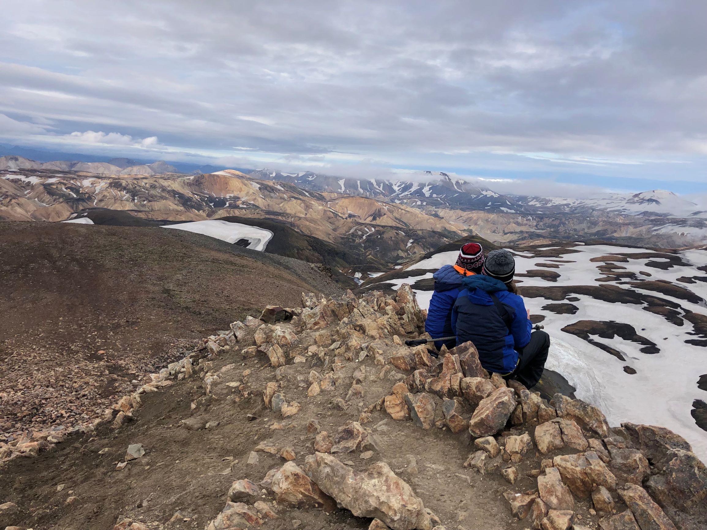
The Fjallabak Nature Reserve was protected in 1979. The aim of the protection is to preserve unique areas so that future generations have the opportunity to enjoy them in the same way as we do. In order for this to happen, there are certain rules of conduct to prevent damage to the environment or disruption of the landscape. Diverse landscape, a unique but fragile ecosystem, desert wilderness and peacefulness are the main characteristics of the Friðland Nature Reserve, and thousands of people visit every year to enjoy the natural resources. Visitors to the area are asked to respect the nature reserve’s rules of conduct and thus contribute so that the aim of the protection can be achieved and so that everyone, as well as our descendants, can fully enjoy the nature of the nature reserve.
The nature reserve is 44,633.4 ha in size and all more than 500 m above sea level. The area is mountainous and shaped by volcanic activity and geothemal heat. The colour palette is broad, mostly due to rhyolite and obsidian in the mountains. Lava fields, rivers and lakes are also prominent in the landscape.
Management and Protection Plan
Work on the preparation of a management and protection plan for the nature reserve is ongoing, and all information about that work can be accessed here in Icelandic.
Access
The northern Fjallabaksleið route (F208) lies between Land and Skaftártunga, through the Fjallabak Nature Reserve. The Landmannaleið route (F225) lies from road 26 towards Landsmannahellir through Dómadalur and connects to road 208 by Frostastaðavatn. The Sígölduleið route (208) lies from Sprengisandsvegur (F26) to Landmannalaugar.
The land here is especially sensitive to damage from traffic, and as a result, drivers are asked to familiarise themselves with road conditions before embarking on a journey through the nature reserve and to not drive outside those roads shown on the map.
Weather Conditions
The average annual temperature in Fjallabak is probably 0–1°C. July is the warmest month of the year, with an average temperature of 7–8°C. The average temperature of the coldest months, January and February, is around -6°C. Bear in mind that the average temperature of each month varies greatly from year to year. Winter conditions and frost can occur at any time of the year. The annual precipitation at Torfajökull glacier, in the southeast corner of the nature reserve, is probably around 2–3 thousand mm but decreases rapidly to the north and northwest and is probbly down to approx. one thousand mm in the northernmost part of the nature reserve.