- Visiting Iceland
- Travel Information
- FAQ
- Protected Areas
- Westfjords
- Breidafjordur
- Dynjandi in Arnarfjordur
- About the area
- Access and services
- Pay for parking
- Nature
- Culture and history
- Drone use at Dynjandi
 Dynjandi in Arnarfjordur
 - Flatey in Breidafjordur
- Hornstrandir
- Hrisey, Reykholahreppur
- Surtarbrandsgil
- Vatnsfjordur
Westfjords - North West
- North East
- Boggvistadafjall
- Dettifoss and a row of waterfalls
- Dimmuborgir
- Public park in Glerardalur
- Reservation in Svarfadardalur
- Godafoss in Thingeyjarsveit
- Hraun in Oxnadalur
- Hverastrytur in Eyjafjordur
- Hverfjall
- Krossanesborgir
- Myvatn and Laxa
- Seljahjallagil
- Skutustadagigar
- Vatnajokull National Park
- Vestmannsvatn
North East - West
- Andakill
- Bardarlaug, Snaefellsbaer
- Blautos and Innstavogsnes
- Breidafjordur
- Budahraun
- Einkunnir, Borgarbyggd
- Eldborg in Hnappadalur
- Geitland, Borgarbyggd
- Grabrokargigar, Borgarbyggd
- Grunnafjordur
- Hraunfossar, Borgarbyggd
- Husafellsskogur, Borgarbyggd
- Kalmanshellir
- Melrakkaey
- Stedji (Staupasteinn)
- The coast by Stapi and Hellnir
- Vatnshornsskogur, Skorradalur
- Snaefellsjokull National Park
West - Search by name
- East
- South West
- Akurey
- Alafoss, Mosfellsbaer
- Astjorn, Hafnarfjordur
- Astjorn and Asfjall, Hafnarfjordur
- Bakkatjorn, Seltjarnarnes
- Blafjoll Public Park
- Borgir, Kopavogur
- Bringur, Mosfellsdalur
- Burfell, Gardabaer
- Eldborg in Blafjoll
- Eldborg in Geitahlid
- Eldey, Reykjanesbaer
- The shore by Kasthusatjorn
- Fossvogsbakkar, Reykjavik
- Gardahraun, Gardabaer
- Galgahraun, Gardabaer
- Grotta, Seltjarnarnes
- Hamarinn, Hafnarfjordur
- Haubakkar, Reykjavik
- Hleinar, Hafnarfjordur
- Hlid, Alftanes
- Hvaleyrarlon and Hvaleyrarhofdi
- Kaldarhraun and Gjarnar
- Kasthusatjorn, Alftanes
- Laugaras, Reykjavik
- Litluborgir, Hafnarfjordur
- Raudholar, Reykjavik
- Reykjanes Public Park
- Skerjafjordur, Gardabaer
- Skerjafjordur, Kopavogur
- Stekkjarhraun, Hafnarfjordur
- Trollaborn, Lækjarbotnar
- Tungufoss, Mosfellsbaer
- Valhusahaed, Seltjarnarnes
- Varmarosar, Mosfellsbaer
- Vifilsstadavatn, Gardabaer
- Vigholar, Kopavogur
South West - South
- Alftaversgigar
- Arnahellir in Leitahraun
- Dverghamrar
- Dyrholaey
- Fjallabak Nature Reserve
- Geysir Area
- Gullfoss
- Herdisarvik
- Jorundur in Lambahraun
- Kerlingarfjoll
- Kirkjugolf
- Oddaflod
- Pollengi and Tunguey
- Skogafoss
- Surtsey
- Area in Thjorsardalur
- Vatnajokull National Park
- Videy in Thjorsa
- Thingvellir National Park
- Thjorsarver
South - Mývatn and Laxá
- National Parks
Protected Areas - Westfjords
- Permits in protected areas
- Operational licence
- Photography, cinematography and drone flying
- Research permit
Permits in protected areas - Drones in protected areas
- Guidelines for using drones in protected areas
- Flights in protected areas
- Apply for permit
Drones in protected areas - Volunteers
- Snæfellsjökull National Park
Visiting Iceland - Wildlife
- Air & Climate
- Ocean & Water
- Industry
- Chemicals
- Frequently asked questions
- Biocides
- Classification and labelling – CLP
- Cosmetics
- Detergents
- Fluorinated greenhouse gases (F-gases)
- Fuel
- Certificate for pest control
- Certificate for professional use of plant protection products
- Plant protection products
- POPs
- REACH
- Safety data sheets
- Supervision, inspection and coercive measures
Frequently asked questions - Biocides
- Classification and labelling
- CLP
- Classification
- Labelling
- Packaging and retention
Classification and labelling - Cosmetics
- Detergents
- F-gases
- Fuel
- Plant protection products
- Authorisation
- Harmonised Risk Indicators
Plant protection products - POPs
- REACH
- Fees
Chemicals - Frequently asked questions
- Importation of Alien Species
- ETS
Industry - Chemicals
- Circular Economy
- Waste
- Waste Management
Circular Economy - The Agency
.svg)
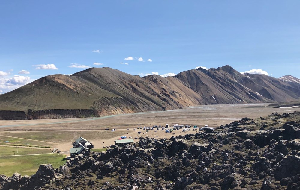
About the area
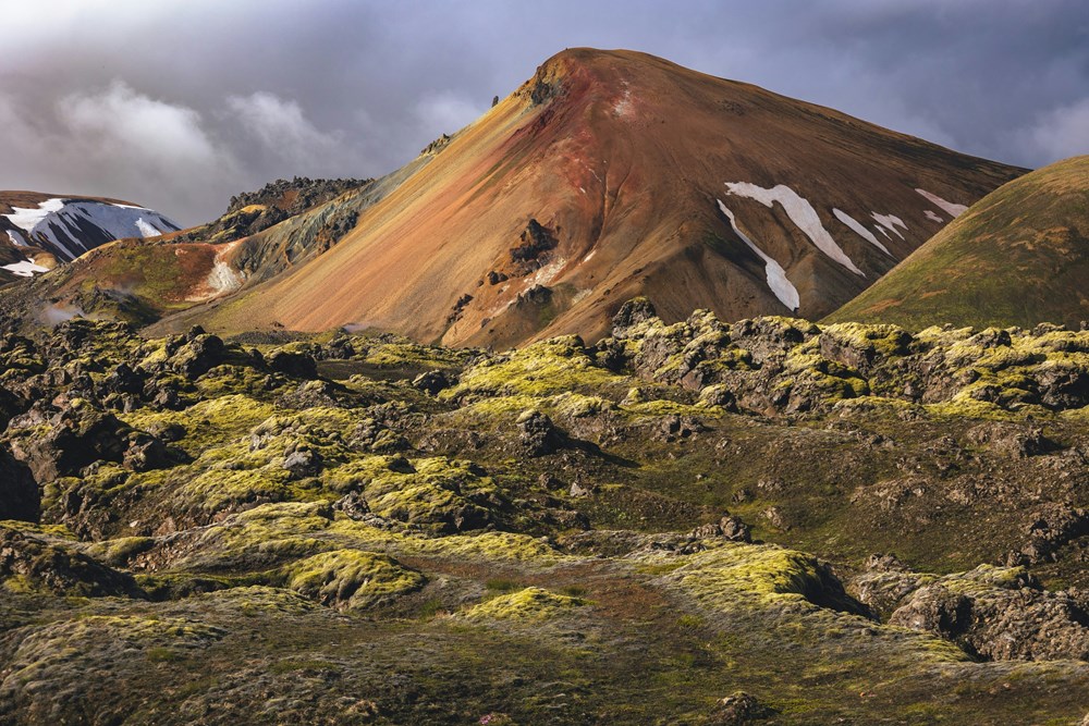
Landmannalaugar is surrounded by vast and colorful mountain ranges, and numerous hiking trails start from the cabin area, where most should be able to find a trail suited to their level. Landmannalaugar is also the starting point of the Laugavegur trail, which is probably Iceland's most famous hiking trail.
Getting there
Access to Landmannalaugar is via road F208 (Fjallabaksleið Nyrðri), but the last 2.5 km are driven on F224 (Landmannalaugavegur). The entire route is passable for four-wheel-drive vehicles, but two rivers need to be crossed right before arriving at Landmannalaugar. It's possible to park at P1 without crossing the rivers, recommended for smaller SUVs and/or inexperienced drivers, then cross over a pedestrian bridge. Always check road conditions prior to driving into the highlands.
Camping and accommodation
In Landmannalaugar, there are cabin accommodations and a camping site operated by The Iceland Touring Association, which also manages the toilets and shower facilities. Cabin wardens provide further information on-site, and it's possible to pay for accommodation and purchase a trail map for the Fjallabak Nature Reserve there.
Throughout the summer, Environment Agency rangers are on-site daily in Landmannalaugar to offer details about hiking trails and lead scheduled ranger-walks