

- Visiting Iceland
- Travel Information
- FAQ
- Protected Areas
- Westfjords
- Breidafjordur
- Dynjandi in Arnarfjordur
- About the area
- Access and services
- Pay for parking
- Nature
- Culture and history
- Drone use at Dynjandi
 Dynjandi in Arnarfjordur
 - Flatey in Breidafjordur
- Hornstrandir
- Hrisey, Reykholahreppur
- Látrabjarg
- For seafarers
Látrabjarg - Surtarbrandsgil
- Vatnsfjordur
Westfjords - North West
- North East
- Boggvistadafjall
- Dettifoss and a row of waterfalls
- Dimmuborgir
- Public park in Glerardalur
- Reservation in Svarfadardalur
- Godafoss in Thingeyjarsveit
- Hraun in Oxnadalur
- Hverastrytur in Eyjafjordur
- Hverfjall
- Krossanesborgir
- Myvatn and Laxa
- Seljahjallagil
- Skutustadagigar
- Vatnajokull National Park
- Vestmannsvatn
North East - West
- Andakill
- Bardarlaug, Snaefellsbaer
- Blautos and Innstavogsnes
- Breidafjordur
- Budahraun
- Einkunnir, Borgarbyggd
- Eldborg in Hnappadalur
- Geitland, Borgarbyggd
- Grabrokargigar, Borgarbyggd
- Grunnafjordur
- Hraunfossar, Borgarbyggd
- Husafellsskogur, Borgarbyggd
- Kalmanshellir
- Melrakkaey
- Stedji (Staupasteinn)
- The coast by Stapi and Hellnir
- Vatnshornsskogur, Skorradalur
- Snaefellsjokull National Park
West - Search by name
- East
- South West
- Akurey
- Alafoss, Mosfellsbaer
- Astjorn, Hafnarfjordur
- Astjorn and Asfjall, Hafnarfjordur
- Bakkatjorn, Seltjarnarnes
- Blafjoll Public Park
- Borgir, Kopavogur
- Bringur, Mosfellsdalur
- Burfell, Gardabaer
- Eldborg in Blafjoll
- Eldborg in Geitahlid
- Eldey, Reykjanesbaer
- The shore by Kasthusatjorn
- Fossvogsbakkar, Reykjavik
- Gardahraun, Gardabaer
- Galgahraun, Gardabaer
- Grotta, Seltjarnarnes
- Hamarinn, Hafnarfjordur
- Haubakkar, Reykjavik
- Hleinar, Hafnarfjordur
- Hlid, Alftanes
- Hvaleyrarlon and Hvaleyrarhofdi
- Kaldarhraun and Gjarnar
- Kasthusatjorn, Alftanes
- Laugaras, Reykjavik
- Litluborgir, Hafnarfjordur
- Raudholar, Reykjavik
- Reykjanes Public Park
- Skerjafjordur, Gardabaer
- Skerjafjordur, Kopavogur
- Stekkjarhraun, Hafnarfjordur
- Trollaborn, Lækjarbotnar
- Tungufoss, Mosfellsbaer
- Valhusahaed, Seltjarnarnes
- Varmarosar, Mosfellsbaer
- Vifilsstadavatn, Gardabaer
- Vigholar, Kopavogur
South West - South
- Alftaversgigar
- Arnahellir in Leitahraun
- Dverghamrar
- Dyrholaey
- Fjallabak Nature Reserve
- Geysir Area
- Gullfoss
- Herdisarvik
- Jorundur in Lambahraun
- Kerlingarfjoll
- Kirkjugolf
- Oddaflod
- Pollengi and Tunguey
- Skogafoss
- Surtsey
- Area in Thjorsardalur
- Vatnajokull National Park
- Videy in Thjorsa
- Thingvellir National Park
- Thjorsarver
South - Mývatn and Laxá
- National Parks
Protected Areas - Westfjords
- Permits in protected areas
- Operational licence
- Photography, cinematography and drone flying
- Research permit
Permits in protected areas - Drones in protected areas
- Guidelines for using drones in protected areas
- Flights in protected areas
- Apply for permit
Drones in protected areas - Volunteers
- Snæfellsjökull National Park
Visiting Iceland - Wildlife
- Air & Climate
- Air pollution during a volcanic eruption
- EU ETS
Air & Climate - Ocean & Water
- Industry
- Chemicals
- Frequently asked questions
- Biocides
- Classification and labelling – CLP
- Cosmetics
- Detergents
- Fluorinated greenhouse gases (F-gases)
- Fuel
- Certificate for pest control
- Certificate for professional use of plant protection products
- Plant protection products
- POPs
- REACH
- Safety data sheets
- Supervision, inspection and coercive measures
Frequently asked questions - Biocides
- Classification and labelling
- CLP
- Classification
- Labelling
- Packaging and retention
Classification and labelling - Cosmetics
- Detergents
- F-gases
- Fuel
- Plant protection products
- Authorisation
- Harmonised Risk Indicators
Plant protection products - POPs
- REACH
- Fees
Chemicals - Frequently asked questions
- Importation of Alien Species
- ETS
Industry - Chemicals
- Circular Economy
- Waste
- Waste Management
Circular Economy - The Agency
Vinna við nýjar heimasíður Umhverfis- og orkustofnunar og Náttúruverndarstofnunar er í gangi. Heimasíða Umhverfisstofnunar er virk á meðan vinnunni stendur. Information in English
.svg)
Geology
.jpg)
Snæfellsjökull National Park – Iceland’s first National Park to extend to the seashore – covers an area of 170 km2 (65 sq. miles). The Park’s southern boundary reaches to Háahraun in the region of Dagverðará while the northern part reaches to Gufuskálar. The coast is varied and alive with birdlife during the breeding season. The coastal plain is mostly covered by lava that flowed from the glacier or nearby craters. The lava is covered with moss but sheltered hollows can be found in many places, filled with a sizable variety of thriving, verdant plants. The omnipresent Snæfellsjökull glacier towers majestically over the Park, with trails of lava and signs of volcanic activity clearly visible on its flanks. On its north side the Eysteinsdalur valley cuts a path up from the plain encircled by alluring steep mountains.
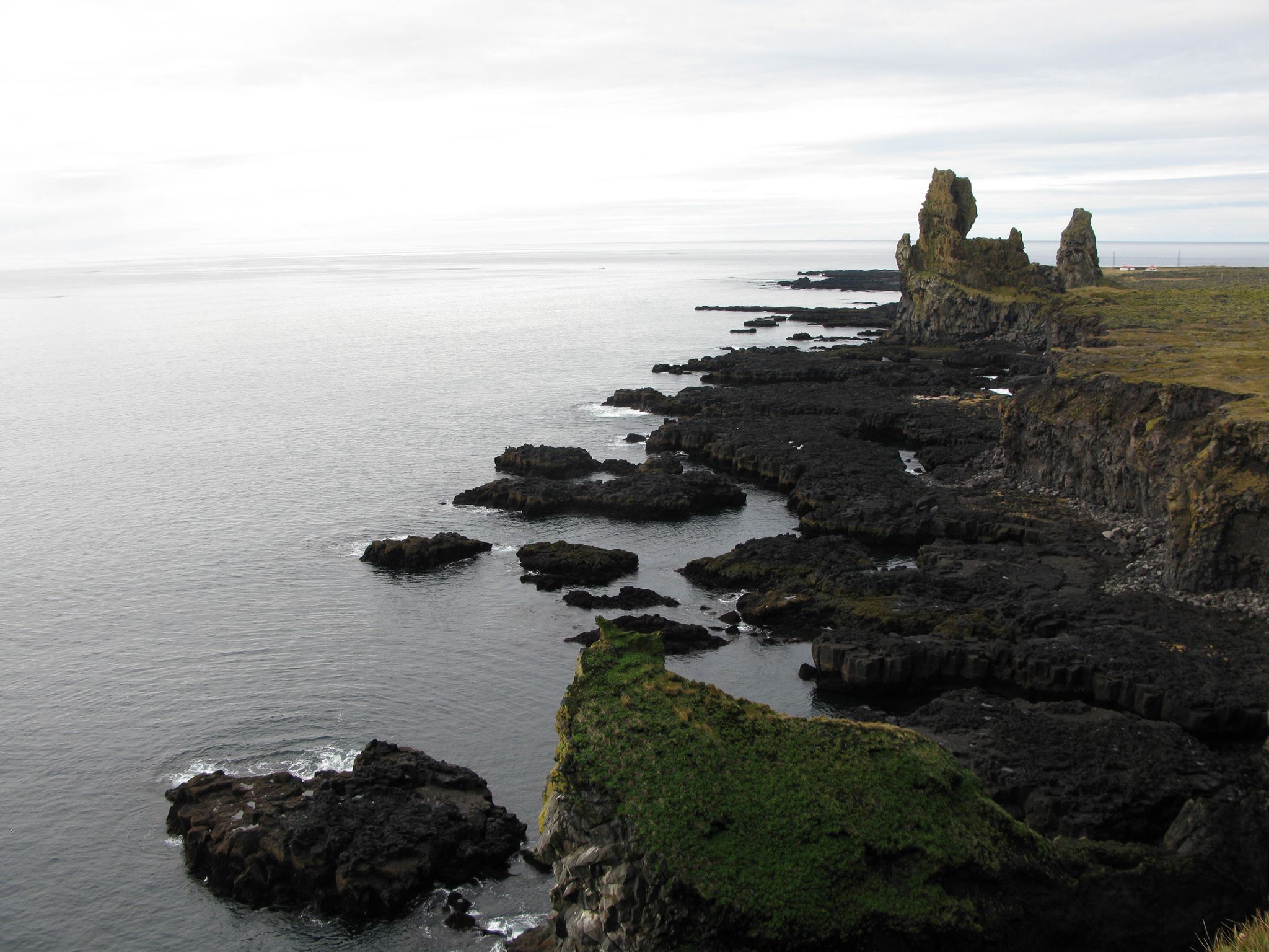
The geology of Snæfellsnes Peninsula is diverse with formations from almost every era of Iceland’s past. The more prominent formations in and around the National Park mainly date from geologically “modern” times back to the last ice age. The hills to the north of the glacier, around Bárðarkista, are of volcanic palagonite tuff, formed during eruptions under the glacier or below the surface of the sea. Svalþúfa is most likely the eastern section of a crater that erupted under the sea, while Lóndrangar is a volcanic plug.
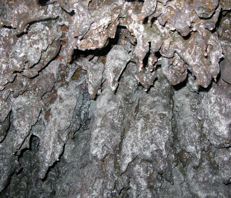
Lava is prominent on the landscape of this National Park with two types present – rough, jagged lava and smooth, ropy lava. Most of the lava emanated from the glacier, from the summit crater or from subsidiary craters on the flanks of the mountain. These lava formations are varied and fascinating, and there is a wealth of caves in the area. Visitors are advised not to enter caves unless accompanied by an experienced guide. Smaller volcanoes – Purkhólar, Hólahólar, Saxhólar and Öndverðarneshólar – are in the Park’s lowlands, surrounded by lava.