

- Visiting Iceland
- Travel Information
- FAQ
- Protected Areas
- Westfjords
- Breidafjordur
- Dynjandi in Arnarfjordur
- About the area
- Access and services
- Pay for parking
- Nature
- Culture and history
- Drone use at Dynjandi
 Dynjandi in Arnarfjordur
 - Flatey in Breidafjordur
- Hornstrandir
- Hrisey, Reykholahreppur
- Surtarbrandsgil
- Vatnsfjordur
Westfjords - North West
- North East
- Boggvistadafjall
- Dettifoss and a row of waterfalls
- Dimmuborgir
- Public park in Glerardalur
- Reservation in Svarfadardalur
- Godafoss in Thingeyjarsveit
- Hraun in Oxnadalur
- Hverastrytur in Eyjafjordur
- Hverfjall
- Krossanesborgir
- Myvatn and Laxa
- Seljahjallagil
- Skutustadagigar
- Vatnajokull National Park
- Vestmannsvatn
North East - West
- Andakill
- Bardarlaug, Snaefellsbaer
- Blautos and Innstavogsnes
- Breidafjordur
- Budahraun
- Einkunnir, Borgarbyggd
- Eldborg in Hnappadalur
- Geitland, Borgarbyggd
- Grabrokargigar, Borgarbyggd
- Grunnafjordur
- Hraunfossar, Borgarbyggd
- Husafellsskogur, Borgarbyggd
- Kalmanshellir
- Melrakkaey
- Stedji (Staupasteinn)
- The coast by Stapi and Hellnir
- Vatnshornsskogur, Skorradalur
- Snaefellsjokull National Park
West - Search by name
- East
- South West
- Akurey
- Alafoss, Mosfellsbaer
- Astjorn, Hafnarfjordur
- Astjorn and Asfjall, Hafnarfjordur
- Bakkatjorn, Seltjarnarnes
- Blafjoll Public Park
- Borgir, Kopavogur
- Bringur, Mosfellsdalur
- Burfell, Gardabaer
- Eldborg in Blafjoll
- Eldborg in Geitahlid
- Eldey, Reykjanesbaer
- The shore by Kasthusatjorn
- Fossvogsbakkar, Reykjavik
- Gardahraun, Gardabaer
- Galgahraun, Gardabaer
- Grotta, Seltjarnarnes
- Hamarinn, Hafnarfjordur
- Haubakkar, Reykjavik
- Hleinar, Hafnarfjordur
- Hlid, Alftanes
- Hvaleyrarlon and Hvaleyrarhofdi
- Kaldarhraun and Gjarnar
- Kasthusatjorn, Alftanes
- Laugaras, Reykjavik
- Litluborgir, Hafnarfjordur
- Raudholar, Reykjavik
- Reykjanes Public Park
- Skerjafjordur, Gardabaer
- Skerjafjordur, Kopavogur
- Stekkjarhraun, Hafnarfjordur
- Trollaborn, Lækjarbotnar
- Tungufoss, Mosfellsbaer
- Valhusahaed, Seltjarnarnes
- Varmarosar, Mosfellsbaer
- Vifilsstadavatn, Gardabaer
- Vigholar, Kopavogur
South West - South
- Alftaversgigar
- Arnahellir in Leitahraun
- Dverghamrar
- Dyrholaey
- Fjallabak Nature Reserve
- Geysir Area
- Gullfoss
- Herdisarvik
- Jorundur in Lambahraun
- Kerlingarfjoll
- Kirkjugolf
- Oddaflod
- Pollengi and Tunguey
- Skogafoss
- Surtsey
- Area in Thjorsardalur
- Vatnajokull National Park
- Videy in Thjorsa
- Thingvellir National Park
- Thjorsarver
South - Mývatn and Laxá
- National Parks
Protected Areas - Westfjords
- Permits in protected areas
- Operational licence
- Photography, cinematography and drone flying
- Research permit
Permits in protected areas - Drones in protected areas
- Guidelines for using drones in protected areas
- Flights in protected areas
- Apply for permit
Drones in protected areas - Volunteers
- Snæfellsjökull National Park
Visiting Iceland - Wildlife
- Air & Climate
- Ocean & Water
- Industry
- Chemicals
- Frequently asked questions
- Biocides
- Classification and labelling – CLP
- Cosmetics
- Detergents
- Fluorinated greenhouse gases (F-gases)
- Fuel
- Certificate for pest control
- Certificate for professional use of plant protection products
- Plant protection products
- POPs
- REACH
- Safety data sheets
- Supervision, inspection and coercive measures
Frequently asked questions - Biocides
- Classification and labelling
- CLP
- Classification
- Labelling
- Packaging and retention
Classification and labelling - Cosmetics
- Detergents
- F-gases
- Fuel
- Plant protection products
- Authorisation
- Harmonised Risk Indicators
Plant protection products - POPs
- REACH
- Fees
Chemicals - Frequently asked questions
- Importation of Alien Species
- ETS
Industry - Chemicals
- Circular Economy
- Waste
- Waste Management
Circular Economy - The Agency
.svg)
Geitland, Borgarbyggd
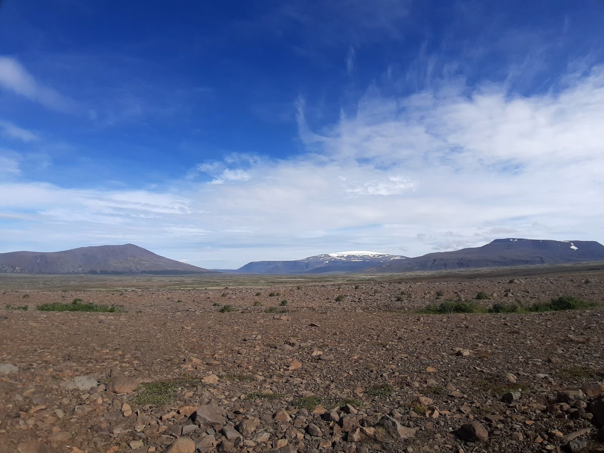
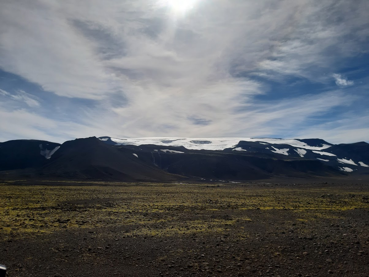
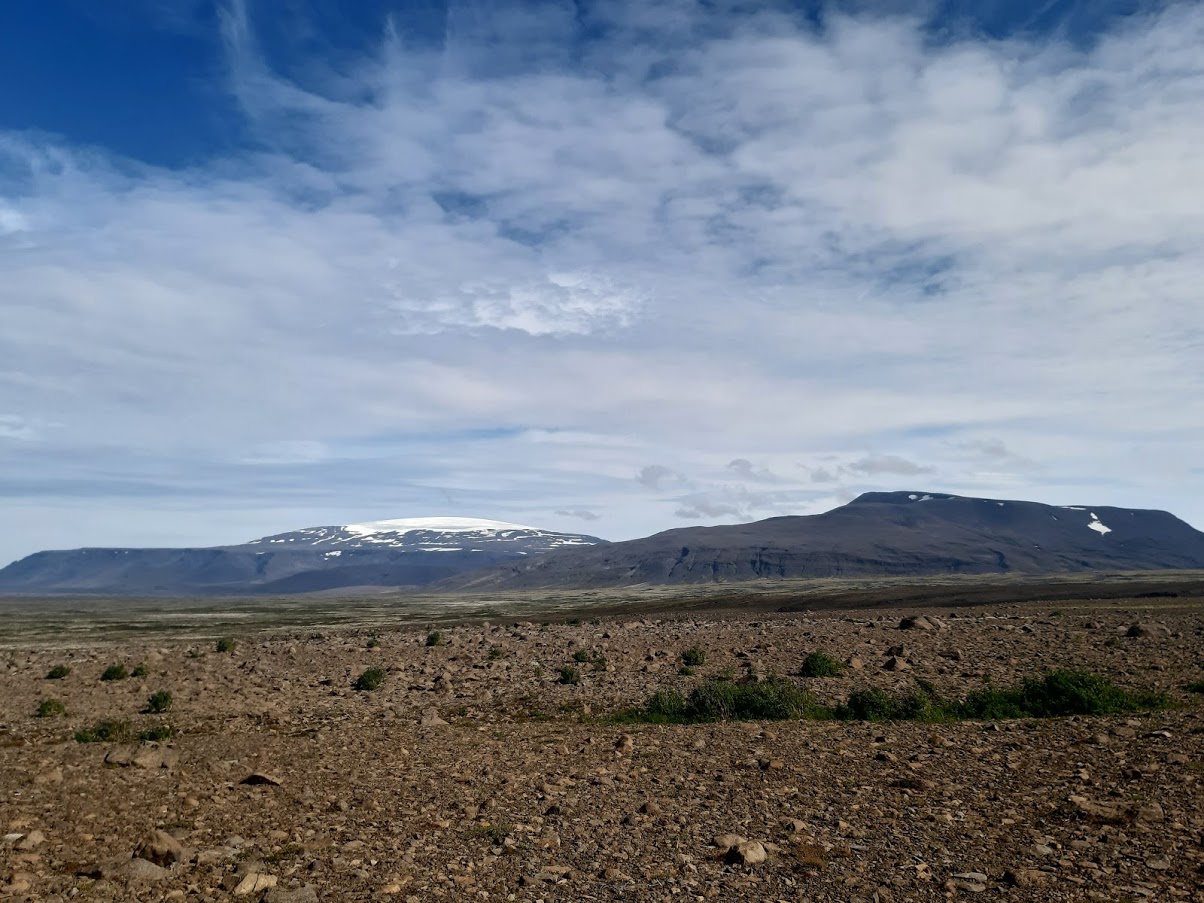
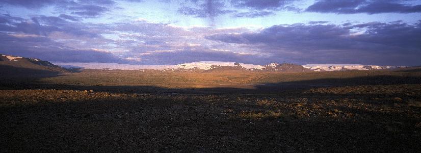
Geitland was protected in 1988. The area is in the rural areas of Borgarfjörður. Geitland covers the area from Langjökull to the south and east and is bounded by Hvítá in the north and Geitá in the west. The area is characterised by vast lava and sand plains, although there are vegetated areas in many places.
Access
General access to the area is allowed provided that visitors conduct themselves properly. The area is isolated by rivers, which makes access to the area more difficult. There is, however, a bridge over Geitá and a road runs through a part of the nature reserve to Langjökull. There are no marked hiking trails within the area.
Rules of Conduct
- Any construction and disturbance of the ground is prohibited without permission from the Environment Agency of Iceland.
- Livestock grazing is prohibited within the nature reserve for the next decade at least.
- Motor vehicle traffic off roads and marked tracks is prohibited.
- General access to the nature reserve is permitted provided visitors observe good conduct.
- It is prohibited to cut vegetation, disturb wildlife or disrupt geological formations.
About the Nature Reserve
Geitland was a summer grazing area in the rural areas of Borgarfjörður for a long time. The area is quite big, or around 122 square kilometers. Within it are glacial rivers, an even-temperature river, waterfalls, glaciers, beautifully shaped mountains, craters, lava fields and sand plains, as well as vegetated areas. Geitland lies between the grounds of the farms Kalmanstunga and Húsafell. Hvíta divides Kalmanstunga and Geitland, and Geitá divides Húsafell and Geitland. Svartá flows through the middle of Geitland and divides it to the north and the south. Svartá usually appears small and harmless but has caused a lot of trouble throughout the years and plays a big part in the fact that wind erosion in the area is quite high. Svartá has its source in Langjökul, like Geitá, and during major thaws and precipitation, it can carry a significant amount of mud and sand. Svartá and Geitá merge into Hvítá at the bottom of Geitland. A large flood occurred in Svartá at the end of summer 2020. This flood caused the average water flow in Hvítá to triple in a short period of time. The consequences of this flood were felt from Geitland and alongside all of Hvítá down to Borgarnes.
Further information about flash floods can be found on the Meteorological Institute’s website.
History
According to Landnáma (Icelandic Book of Settlement), Úlfur Grímsson settled in Geitland and many great families descend from him, including Sturlungar. There was a settlement in Geitland until the turn of the century in 1600, and signs of it are still visible in two places. A folktale exists about the hot spring Skrifla, as the hot spring is said to have moved from Geitland down to Reykholt where it is now. According to legend, Skrifla used to be near a farm in Geitland called Reykholt. The bloody clothes of an innocent man who was killed are said to have been washed in the hot spring. In protest, Skrifla disappeared underground and moved down into the countryside. Skrifla came up in Teitsgil, east of Bæjarfell in Húsafell, then in Laugarbrekkur, located above the Húsafell farm. It came up next in Stór-Ás and then in stages down to Reykholt where Skrifla is still located today. Skrifla is said to have left a trail of hot pools in its wake (Kristleifur Þorsteinsson, 1938). On the Cultural Heritage Agency of Iceland’s digital map, you can see to relics of days gone by in Geitland, Kot (Geitland) and Hamraendar. Both these sites contain remains from the past, such as ruins and field boundary walls. The last farmer in Kot is thought to have been Jökla-Helgi. He lived in the 17th century, and numerous residents of Borgarfjörður can trace their lineage to him.
Utilisation
Geitland has been utilized by farmers and their workers and is still partly utilised. Geitland is a great site for berry picking, especially crowberries. There is a lot of Iceland moss in Geitland, which was considerably harvested in the past. There are also a lot of juniper bushes, and the berries used to be picked for distilling liquor. Geitland was considered good ptarmigan grounds, and ptarmigan hunting for export was common. Geitland was an off-farm grazing area for a long time and was used for livestock grazing in both summers and winters during that time. Undoubtedly the forest was utilized, as there are mentions of forest utilization in old sources when Geitland was owned by the church. There was a millstone mine in Geitland that was used up until the end of the 19th century. Farmers in Húsafell fetched millstone blocks on horses and cut them down to millstones and sold them far and wide.
Ásgeir Bjarnason & Kristleifur Þorsteinsson (1938). The District History of Borgarfjörður. Reykjavík: Ísafoldarprentsmiðja hf. (Vol. 2).
Kristleifur Þorsteinsson (1944). From the Borgarfjörður settlements. Reykjavík: Prentsmiðjan Leiftur HF. (Vol. 1).