

- Visiting Iceland
- Travel Information
- FAQ
- Protected Areas
- Westfjords
- Breidafjordur
- Dynjandi in Arnarfjordur
- About the area
- Access and services
- Pay for parking
- Nature
- Culture and history
- Drone use at Dynjandi
 Dynjandi in Arnarfjordur
 - Flatey in Breidafjordur
- Hornstrandir
- Hrisey, Reykholahreppur
- Surtarbrandsgil
- Vatnsfjordur
Westfjords - North West
- North East
- Boggvistadafjall
- Dettifoss and a row of waterfalls
- Dimmuborgir
- Public park in Glerardalur
- Reservation in Svarfadardalur
- Godafoss in Thingeyjarsveit
- Hraun in Oxnadalur
- Hverastrytur in Eyjafjordur
- Hverfjall
- Krossanesborgir
- Myvatn and Laxa
- Seljahjallagil
- Skutustadagigar
- Vatnajokull National Park
- Vestmannsvatn
North East - West
- Andakill
- Bardarlaug, Snaefellsbaer
- Blautos and Innstavogsnes
- Breidafjordur
- Budahraun
- Einkunnir, Borgarbyggd
- Eldborg in Hnappadalur
- Geitland, Borgarbyggd
- Grabrokargigar, Borgarbyggd
- Grunnafjordur
- Hraunfossar, Borgarbyggd
- Husafellsskogur, Borgarbyggd
- Kalmanshellir
- Melrakkaey
- Stedji (Staupasteinn)
- The coast by Stapi and Hellnir
- Vatnshornsskogur, Skorradalur
- Snaefellsjokull National Park
West - Search by name
- East
- South West
- Akurey
- Alafoss, Mosfellsbaer
- Astjorn, Hafnarfjordur
- Astjorn and Asfjall, Hafnarfjordur
- Bakkatjorn, Seltjarnarnes
- Blafjoll Public Park
- Borgir, Kopavogur
- Bringur, Mosfellsdalur
- Burfell, Gardabaer
- Eldborg in Blafjoll
- Eldborg in Geitahlid
- Eldey, Reykjanesbaer
- The shore by Kasthusatjorn
- Fossvogsbakkar, Reykjavik
- Gardahraun, Gardabaer
- Galgahraun, Gardabaer
- Grotta, Seltjarnarnes
- Hamarinn, Hafnarfjordur
- Haubakkar, Reykjavik
- Hleinar, Hafnarfjordur
- Hlid, Alftanes
- Hvaleyrarlon and Hvaleyrarhofdi
- Kaldarhraun and Gjarnar
- Kasthusatjorn, Alftanes
- Laugaras, Reykjavik
- Litluborgir, Hafnarfjordur
- Raudholar, Reykjavik
- Reykjanes Public Park
- Skerjafjordur, Gardabaer
- Skerjafjordur, Kopavogur
- Stekkjarhraun, Hafnarfjordur
- Trollaborn, Lækjarbotnar
- Tungufoss, Mosfellsbaer
- Valhusahaed, Seltjarnarnes
- Varmarosar, Mosfellsbaer
- Vifilsstadavatn, Gardabaer
- Vigholar, Kopavogur
South West - South
- Alftaversgigar
- Arnahellir in Leitahraun
- Dverghamrar
- Dyrholaey
- Fjallabak Nature Reserve
- Geysir Area
- Gullfoss
- Herdisarvik
- Jorundur in Lambahraun
- Kerlingarfjoll
- Kirkjugolf
- Oddaflod
- Pollengi and Tunguey
- Skogafoss
- Surtsey
- Area in Thjorsardalur
- Vatnajokull National Park
- Videy in Thjorsa
- Thingvellir National Park
- Thjorsarver
South - Mývatn and Laxá
- National Parks
Protected Areas - Westfjords
- Permits in protected areas
- Operational licence
- Photography, cinematography and drone flying
- Research permit
Permits in protected areas - Drones in protected areas
- Guidelines for using drones in protected areas
- Flights in protected areas
- Apply for permit
Drones in protected areas - Volunteers
- Snæfellsjökull National Park
Visiting Iceland - Wildlife
- Air & Climate
- Ocean & Water
- Industry
- Chemicals
- Frequently asked questions
- Biocides
- Classification and labelling – CLP
- Cosmetics
- Detergents
- Fluorinated greenhouse gases (F-gases)
- Fuel
- Certificate for pest control
- Certificate for professional use of plant protection products
- Plant protection products
- POPs
- REACH
- Safety data sheets
- Supervision, inspection and coercive measures
Frequently asked questions - Biocides
- Classification and labelling
- CLP
- Classification
- Labelling
- Packaging and retention
Classification and labelling - Cosmetics
- Detergents
- F-gases
- Fuel
- Plant protection products
- Authorisation
- Harmonised Risk Indicators
Plant protection products - POPs
- REACH
- Fees
Chemicals - Frequently asked questions
- Importation of Alien Species
- ETS
Industry - Chemicals
- Circular Economy
- Waste
- Waste Management
Circular Economy - The Agency
.svg)
The coast by Stapi and Hellnir
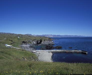
The Stapar and Hellnar beach was protected in 1979. Many beautiful and striking rock formations are found by the ocean in this area. Striking rock formations have been formed by the surf. Hellnahraun is believed to have flowed from a crater near Jökulháls which is now covered by a glacier. The area has i.a. striking fissures that the sea has carved out of the rock. Birdlife in the area is robust. The beach was previously a big fishing port, as it has a good landing area for boats. The lava field is believed to be 3900 years old.
The nature reserve is 134.4 ha in size.
Where Is the Beach?
Topography
From the south of Snæfellsnes peninsula, the mountain range is visible from Reykjanes and inland towards the glaciers up from Borgarfjörður. To the east and closer is the Snæfellsnes mountain range, with the lush green Staðarsveit with its yellow sand beaches at its roots. Bjarnarfoss falls from the rocky slopes of the hill over Búðir, and in it, stands a Lady of the Mountains, with the spray forming a shawl over her head and shoulders. She can best be seen from the road at the turn-off to Búðir and above from Fróðárheiði heath.
High north of Búðir is Mælifell, an odd but beautiful mountain that most likely was formed in a sub-glacial eruption. North of Búðarhraun is Axlarhyrna. North of Arnarstapi is Stapafell, a 526 m high tuff mountain. It’s an easy hike most of the way up the northern ridge of Stapafell but gets increasingly steeper as you get higher. Fellskross, at the top of the mountain, is a difficult climb. The crown jewel is in the west, Snæfellsjökull glacier itself, said to hold great secrets. The glacier is believed to be one of the seven main energy centres of the world. Bárður Snæfellsás, the area’s protector, lives in it, and the way to the center of the earth might be hidden there. The glacier is rather easy to hike, nowhere too steep except for Miðþúfa at the top. All well-equipped tourists should therefore be able to walk on Snæfellsjökull; the weather and glacial fissures are the main things to consider.
The Snæfellsjökull volcanic system forms a strong cohesive landscape and shows evidence of unique volcanic activity, both from the most recent ice age and after it ended. The system is approx. 30 km in length and stretches from Mælifell in the east to Öndverdanes in the west and may even extend further. At least 20 lava fields belong to the system. The lifeblood of the volcanic system is a magma chamber that lies several kilometres under the glacier. Snæfellsjökull is an old strato-volcano, with alternate explosive eruptions and effusive eruptions. Lava streams flowed down the mountain slopes and are visible in many places, and some of them even reach the sea. The crater bowl at the top of the glacier is approx. 200 m deep. Its rim has three peaks, with the middle peak being the highest, approx. 1446 metres high.
Even though it looks peaceful on sunny and still days, the area takes on a different look when storms are blowing and the ocean waves crash onto the shore. Some days, the fog looms over it and hides all.
Interesting
Wildlife
In the upper layers of the ocean, where there is enough light, photosynthesis happens. The plankton, most commonly made up of unicellular organisms, moves with the current. Plankton live on phytoplankton, and fish live on plankton. Fish are eaten by other fish, sea birds, sea mammals and humans. So it’s safe to say that the nature reserve relies on plankton, the foundation of the ocean’s food chain.
The nature reserve has a diverse birdlife. Of seagulls, kittiwake is the most common. The kittiwake lays two eggs and glues its nest together with saliva and droppings on cliff edges and the narrow ledges of the sea cliffs. The great black-backed gull tends to stay close to nesting areas and mostly catches beach animals, pelagic fish and fish waste. Other gull species and fulmars are also common. The Arctic tern is a majestic bird and fiercely protective of its young. In order to enjoy the bright summer nights, the tern has adapted a special flying technique, and its long-distance flights can reach up to 20,000 km a year. Shags nest in clusters on low cliffs and islets. During the nesting season, the full-grown birds have a feathered crest on top of their head. The shag is a nimble diver.
Eider duck is the most common coastal duck species. Red-necked phalaropes can often be seen in the ponds above Pumpa. The bird is known for spinning in the water when looking for food. The female may have more than one male partner at a time, and they sit on the eggs and care for the young. Seals swim outside the beach and the killer whale, porpoise and minke whale are the most common whale species. On good days, you can see schools of salmon from the pier and pods of leaping dolphins.
Cultural Heritage
Arnarstapi and Hellnar and other nearby place names all reflect the saga of Bárður Snæfellsás, who was half man and half troll. Bárður landed at Djúpalón and bathed in Bárðarlaug. He built a large farm nearby and called it Laugabrekka, where he lived while he dwelt among humans.
Þorkell, Bárður’s brother, lived at Arnarstapi. He had two sons, Rauðfeldur and Sölvi. Bárður’s daughters were brought up in Laugarbrekka and were greatly admired. Helga was the oldest. The sons of Þorkell and the daughters of Bárður were playmates. Once, when the pack ice was close to shore, Rauðfeldur pushed Helga out to sea on an iceberg. Helga drifted over to Greenland and was not harmed, but her father was furious. He threw Rauðfeldur into Rauðfeldargjá and pushed Sölvi off Sölvahamar. After that, Bárður disappeared into the glacier. His riches are said to be stored in Bárðakista, a chest-shaped tuff mountain that rises from Saxhólsdalur. Many believe that Bárður guards the area around the glacier. A statue of Bárður Snæfellsás by Ragnar Kjartansson stands near the beach at Arnarstapi.
In previous centuries, fishing grounds were found in many places out from the glacier. Landing spots are dangerous in many places and conditions difficult, so fishing has ceased from there in spite of the proximity to good fishing grounds. When fishing boats became motorised, improvements were made to the dock at Arnarstapi in 1933 and in Hellnar in 1964, but the dock in Hellnar was later damaged in a storm.
Arnarstapi
Arnarstapi once had a thriving community. Around 150 people, for example, lived there in 1707, and it was one of the harbours run by the Danish trading monopoly. Few families now live year-round in Arnarstapi. During the summer, however, the place is filled with both bird and human life, with a lively small-boat fishing industry and summer cottage community. The harbour at Arnarstapi is surrounded by basalt columns, fissures and small caves. It’s a good landing area for small boats. Barnaþúfa and Barnaþúfubarð are close to the harbour. A bit further out to sea is a rock called Arnarklettur. Even further are Kórsnef and Pálsklettur. Between Lendingarklettur and Arnarklettur, there is a peculiar rocky dock named Kór. West of Pálsklettur is a long and narrow inlet with a gravel beach. It’s called Pumpa. Just west of the lighthouse are Stapagjár. They are great caves that the sea has broken and filed into the columnar basalt cliffs. There are three canyons, Eystrigjá, Miðgjá and Músargjá. There is active birdlife in the canyons, mostly black-legged kittiwake.
Hellnar
For centuries, Hellnar was one of the largest fishing ports in the area. In early 17th century, it had a population of approx. 200 people, some of whom had livestock and others who were workers. Many archaeological remains in the area provide a glimpse of days gone by. The beach is under Gróuhóll, where the parking lots are. East of the cove is a spur of rock named Valasnös. There you’ll find Baðstofa, one of the most unusual caves in Iceland. In the cliffs above the beach is Sauðahellir, an old sheep sheltering cave open at both ends.
Hellnarkirkja church was built in 1945 in a beautiful spot. A church was first built there in 1883.
Access
The Environment Agency of Iceland is responsible for the management of the nature reserve and organising land protection. Visitors are welcome and are encouraged to explore. Off-road driving results in open wounds in the ground and can form paths in areas you shouldn’t drive through. Therefore, off-road driving is prohibited. Special precaution must be taken in the vicinity of bird nesting areas. If the birds are disturbed and leave their nests for too long, the nesting can fail. Do not cut vegetation or disturb wildlife, and do not damage geological formations. Take all garbage to the next garbage container, thus ensuring that the beach stays clean.
Old public roads run through the area and are a valuable cultural heritage. Such roads should be used, as this allows them to live on as part of the traffic network, as well as being a connection to cultural heritage and a reminder of the area’s economic history. They blend well with the surroundings, and visitors experience a close connection to nature.
It is important that we all respect and follow these rules. The earth belongs to all of us, so let’s treat it well so that the coming generations can also enjoy it fully. Respect nature and all its diversity of life and landscapes.
There are places in Arnarstapi and Hellnar that provide indoor accommodation. There are campsites there as well, but camping in the nature reserve itself is prohibited. Various recreation options and services are available to visitors. There are park rangers, that work in Snæfellsjökull National Park, that oversee the nature reserves.
The aim of the protection is to preserve Iceland’s nature in a way that gives people the opportunity to enjoy it. With the nature reserves, land is retained for the normal progression of nature, outdoor activities and people’s experience of nature. The increased consciousness of the public and active participation in nature conservation are fundamental to reaching these goals. Have fun!
Hiking trails
Hiking Trails in the Nature Preserve and Surrounding Areas
The main hiking trails in the nature reserve are marked, and organised hikes guided by the ranger are offered in the summer.
You can hike from the Búðir reserve over to the beach by Arnarstapi and Hellnar. The hike takes an estimated 6–8 hours.
An old public road leads west past Sölvahamar at the foot of the glacier. There you’ll find the Sölvahamar ruins. These are protected and on the archaeological remains register. Hiking to Sölvahamar from Arnarstapi takes under one hour and is well worth your while.
The area between Arnarstapi and Hellnar, from the sea up to the glacier, is a large lava field known as Hellnahraun. The track Neðstagata crosses the lava alongside the beach. From there, the effects of powerful natural forces on the landscape are evident. The hike between Arnarstapi and Hellnar takes about 30 minutes.